 Remote Sensing and GIS
 Remote Sensing techniques have been used in many applications. In the area of land-use and land-cover, agriculture, soil mapping, forestry, city planning, archaeological investigations, military observation, and geomorphological surveying applications are the major users.
GIS is the study of natural and human made phenomena and processes from a spatial perspective. These measurements emphasize three types of properties commonly associated with these types of systems: elements, attributes and relationships. We are specialised in surveying, data analysis, various kind of mapping, developing decision making systems, sattelite imagery analysis, Photogrammetry, etc. We are specialised in LiDAR mapping with the data produced for various purposes like Tourism development, DEM, DTM, POI, Orthorectification, 3D Analysis, etc.
 Climate Change Studies
 We work on climate change issues focuses on three main themes:
Climate Change Vulnerability and Resilience - Building adaptation and disaster risk reduction policies that contribute to eradicating poverty.
Climate Change Knowledge and Learning - Improving our understanding of whose voices and whose knowledge counts in climate policies.
Low-carbon Development - Meeting the challenge of achieving sustainable economic growth.
 Environmental Impact Assessment(EIA)
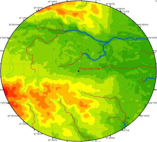
 The most important step in the process of obtaining environmental clearance under the EIA notification is for the project proponent to conduct an environmental impact assessment of the project. We work as an environmental consultant to prepare an EIA report. Particularly we give consultancy in the area of Hydro-geology, Hydrology, Land Use Land Cover, Drainage Pattern, Geo-physical, 3D Digital Elevation Model(DEM), GIS, Remotesensing and Satellite Imagery Analysis.
 Hydrology
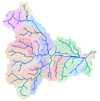
 Domains of hydrology include hydrometeorology, surface hydrology, hydrogeology, drainage basin management and water quality, where water plays the central role. Hydrology is the study of the movement, distribution, and quality of water on Earth and other planets, including the hydrologic cycle, water resources and environmental watershed sustainability. Our hydrologists working in the fields of earth and environmental science, physical geography, geology, glaciology, civil and environmental engineering. We have specialised experts in the different field of Hydrology and expertised to make integrated studies of complex problems.
Hydrologic models are simplified, conceptual representations of a part of the hydrologic cycle. They are primarily used for hydrologic prediction and for understanding hydrologic processes. Two major types of hydrologic models can be distinguished as one is Models based on data and another is Models based on process descriptions. We have done studies on different aspects of hydrology and hydrological models like ArcSWAT, GLOB, Runoff Models, NetLogo, etc.
